Documentation does not help for validation intersect error #68
Comments
|
following up with additional tests. The databases produced by ZoneDetect now show the lat/long for Rankin or Cambridge Bay as not being in any zone, so this removes coverage. |
|
Well, looks like some OSM editors failed to properly add all ways to the Cambridge Bay timezone relation after making some edits. Here is what the relation looks like when fetched from Overpass Turbo:
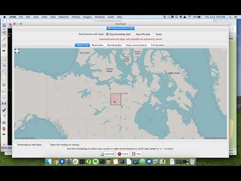
The relation must be fixed in OSM by manually adding back all of the affected ways to the Cambridge Bay timezone relation. Unfortunately, OSM relations get corrupted like this all the time even for very important relations - I've had to fix the USA/Canada border once! I typically use JOSM to do this and here is a video that includes using the relation editor that might help. As there hasn't been a new timezone database release since 2019a, I'm not able to make this a priority for myself right now. If at all possible, I'd recommend downloading a dataset from the releases because, as you have observed, OSM data corruption issues routinely break the builder script. |

|
I just fixed both the Cambridge Bay and Rankin Inlet relations in OpenStreetMap. Turns out the border for Serbia also had this issue, so I fixed that as well! I also recorded and made a video of my fixing the Cambridge Bay timezone and added it to the wiki. Hope this helps in the future. |
At one time, I had Yellowknife overlapping with Cambridge Bay forcing a "Validation error: ... intersects ... area: ###" error which is now not happening anymore since I had to remove Cambridge Bay from being downloaded at all, see below. The documentation for this error says:
"If the area should be allowed to overlap, then an entry for the zone overlaps should be defined in the expectedZoneOverlaps.json file." How would this entry be defined? I see a "bounds" field with two sets of longitude/latitude (yes, reversed from the normal latitude/longitude). How are these values arrived at? Is there any easy way to plot these polygons and fix them and then write out the fixed file? My only option now is to remove one or both of the files, which is irritating as my dataset is then not complete. As of now, it looks like someone is trying to fix Cambridge Bay since I did not get this malformed data error before for this timezone.
Also, the following is a question as well as another documention issue, basically what is the contact information for anybody at OpenStreetMap to inform about files throwing errors?
Trying to regenerate the shape files so I have all correctly generated using 'node --max-old-space-size=8192 index.js', I have two "Invalid geojson received in Overpass Result" errors, forcing me to remove these timezones and boundaries from the json in order to continue. I understand these are problems with the actual OpenStreetMap data. Can you tell me who I could contact to get these files fixed? Is there any way for me to easily fix them myself?
Thanks.
The text was updated successfully, but these errors were encountered: